During the April 10 session, Prime Minister Nikol Pashinyan responded to MP Davit Arushanyan’s question about news reports that Armenia had submitted maps to the United Nations at various times, which did not include Nagorno Karabakh and instead showed Tigranashen as an Azerbaijani enclave.
“A recent publication by a research site revealed maps sent by the Republic of Armenia to the United Nations. It is important to note that each UN member country can send maps of its sovereign territory. However, Nagorno Karabakh was not included in the maps sent in different years. Additionally, Tigranashen was included as an Azerbaijani enclave.” said the MP, then asked Nikol Pashinyan’s opinion regarding this issue.
“I must say we are currently carrying out an official investigation on that particular topic. We are questioning whether the Republic of Armenia provided the UN with maps at some point in time. We have noticed certain changes in the maps, which has raised some questions. It raises some questions, and these questions must be answered. And at the moment, we are trying to find out the cause-and-effect relationship. As far as we know, the last time a similar map was changed was in 2013. We are currently investigating to find out what exactly happened. I can say one thing: we found out that there is no record of the sending of those maps to the Ministry of Foreign Affairs, which is a strange fact. We are still investigating and trying to find out what happened.” said the Prime Minister.
“Verified” discovered that the maps discussed were not provided by Armenia but developed by the United Nations.
Which publication is being discussed?
The officials were discussing the article published on April 2 by a fact-checking platform. The article examined the maps published by the United Nations in different years since Armenia gained independence, emphasizing that the Republic of Armenia provided these maps.
“A Member State of the United Nations may provide maps of its sovereign territory to the Organization for archiving and circulation purposes. “At the same time, the maps provided by the states do not necessarily comply with the instructions defined in the Guidelines for the publication of UN Maps, as they refer exclusively to the maps developed by the organization’s secretariat online and on other media,” the publication states.
On April 3, the matter was also covered by “First Channel”. In the reportage, MP Arpi Davoyan criticized the former authorities for providing the UN with such a map.
On April 11, Channel 5 covered the topic. The journalist interviewed Dzyunik Aghajanyan, who had previously served as Armenia’s special envoy to the UN. Aghajanyan claimed that Armenia had never submitted such maps to the UN, further clarifying that the maps in question were based on the Soviet-era maps.
UN sources
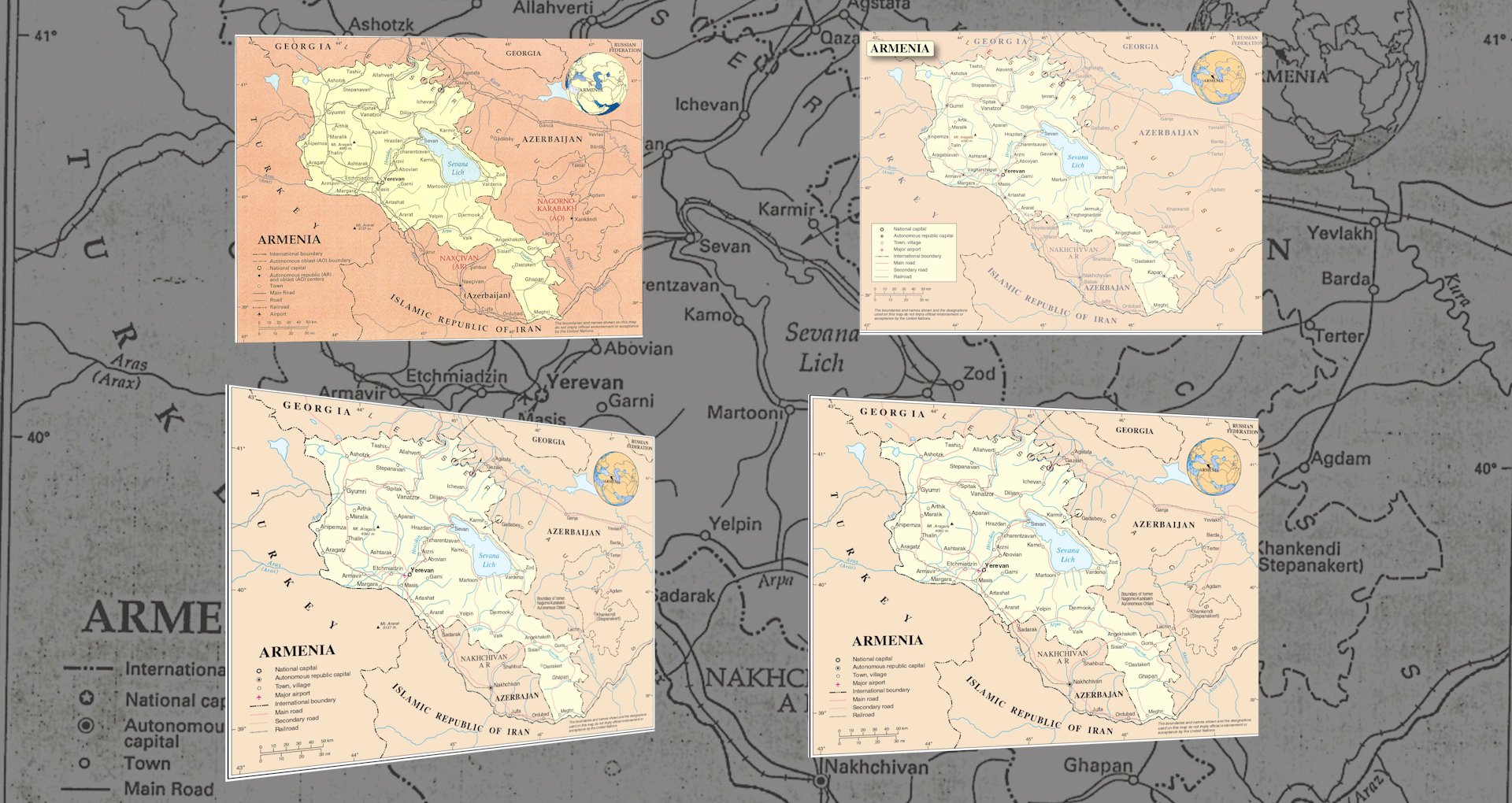
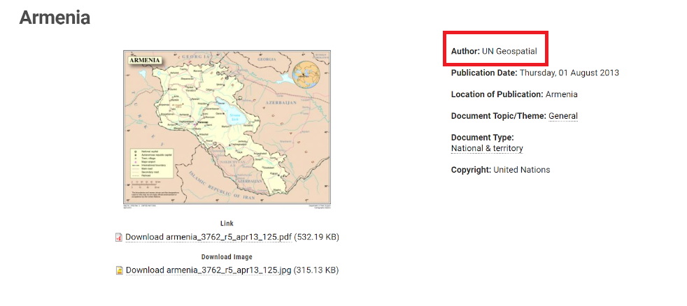
The maps Armenia supposedly sent to the UN can be accessed on the organization’s website under the “General Maps” section. The page description clarifies that the United Nations created these maps for general use and organizational purposes. The UN has been developing similar maps since its establishment in 1946.
On the UN website, you can find the latest map of Armenia published in 2013. It attributes the relevant UN agency as the “author” of the map.
In addition, there is a note specifying that the maps on the website are unofficial and do not indicate that the UN has approved or acknowledged the mentioned borders.
As mentioned, the UN Cartography Department, which prepared the maps, is listed as the author in the UN Digital Library, where they are published.
According to the Fact-Checking Platform, the maps provided by countries may not always follow the guidelines for the Publication and Dissemination of UN Maps and Documents. This is because these guidelines are meant only for the organization’s secretariat to publish maps online and on other media.
However, the maps available in the UN digital library belong to the class of “maps developed on the Internet and other media,” and the reference to UN guidelines only applies to maps attached to documents provided to the organization by countries. When a country submits a document to the UN, the name of that country is listed as the author of the document. For instance, in a letter sent by the Permanent Representative of Armenia to the UN last November, the author section of the document mentions “Armenia.” You can find all the documents authored by Armenia at this link, but there are no maps available. However, you can find maps of Armenia published by the United Nations between 1993 and 2013 at this link.
Thus, in the sources of the UN, there is no indication that the countries provide the maps themselves; on the contrary, according to the organization, the cartography department of the UN prepares them. The guideline also notes that many of the United Nations’ published maps are produced by their cartographic department.
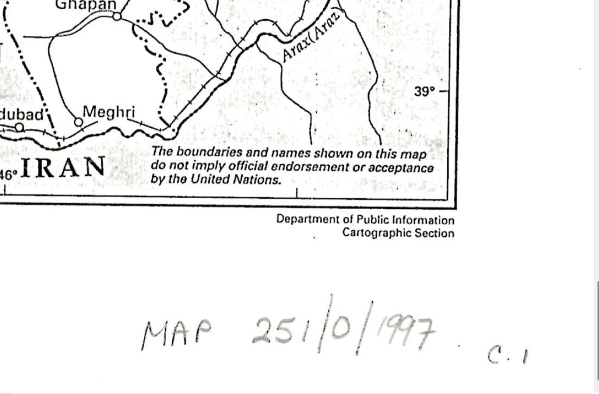
“Others are done by outside firms, or prepared in the field, or taken from non-United Nations sources. A map or maps may form the principal part of a United Nations document or be ancillary to other materials.”
The question about the basis on which the relevant UN department prepares the maps is still unanswered. It is unclear whether the UN specialists work with the respective governments of the countries when creating maps or not. “Verified” has sent a request to the United Nations and we will update the article as soon as we receive a response.
The former permanent representatives of Armenia at the UN also deny
“Verified” also had conversations with two of Armenia’s former permanent representatives at the United Nations, Karen Nazaryan (who is now an advisor to the deputy prime minister) and Armen Martirosyan. Both of them denied that Armenia submitted any map to the UN during their tenure. Their responses are provided below.
Armen Martirosyan, 2003-2009
“I neither received such instruction nor, of course, did I provide it. Nothing like this happened from 2003 to 2009; I cannot say what happened after that,” said Armen Martirosyan.
To the question of whether there was any other way to transfer the maps to the UN, Martirosyan replied that typically everything is done through the UN and that anything else would be merely hypothetical, according to the former ambassador.
“Typically, a country’s government communicates with the United Nations or any other international organization through their embassy in the respective country. However, we have not had any communication regarding maps for the past six years. Even during my tenure, the UN did not request any maps. Despite having discussions about Karabakh for many years, there has been no talk about maps.”
Karen Nazaryan, 2009-2014
“We did not provide any map of that kind. To the best of my recollection, maps that could be used as a reference are limited to federal missions or other institutions not affiliated with the United Nations. As far as I know, member states do not provide maps. During my tenure, neither any UN entity nor our embassy or I provided official or unofficial maps.” Karen Nazaryan stated that “no UN entity approached our diplomatic mission or me for any consultation or discussion regarding publishing or reproducing any maps.”
Ani Avetisyan
Ophelia Simonyan